Watershed Management and Nature Reserves
Water supply, water quality, drainage, storm water runoff, water rights, and the overall planning and utilization of watersheds are the features of watershed that need to be managed.
The principles of watershed management will also be discuss as well as integrated watershed management.
The importance of watershed will be learnt in this unit. In order to complement this unit, nature reserves will be defined and the well-known nature reserves in some African countries will be unfolded.
What are Watersheds?
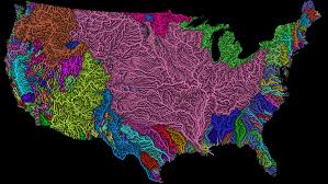
Watersheds are areas of land defined by the flow patterns of rainwater or melting snow and ice when it is determined by topography of a region rather than political boundaries.
In more general terms a watershed is a geographic area where all the water, sediments, and dissolved materials drain to a common outlet like a stream, river system, reservoir, lake, underground aquifer, estuary, wetland, sea, ocean or other body of water.
It can also be thought of as an area that “catches” water and routes it to a common basin, channel, or network of channels.
In the technical sense, a watershed refers to a divide that separates one drainage area from another drainage area. Watersheds drain into other watersheds in a hierarchical pattern, with smaller sub-watersheds combining into larger watersheds.
However, the term is often used to mean a drainage basin or catchment area itself. Other terms that are used to describe a watershed are catchment, catchment basin, drainage area, river basin, and water basin.
Watersheds are similar but not identical to hydrologic units, which are drainage areas delineated so as to nest into a multi-level hierarchical drainage system.
Hydrologic units are designed to allow multiple inlets, outlets, or sinks. In a strict sense, all watersheds are hydrologic units but not all hydrologic units are watersheds.
The watershed acts as a funnel by collecting all the water within the area covered by the basin and channeling it to a single point.
Each watershed or drainage basin is separated topographically from adjacent basins by a geographical barrier such as a ridge, hill or mountain in hilly country, but in flat country especially where the ground is marshy, the divide may be invisible with just a more or less national line on the ground on either side of which falling raindrops will start a journey to different rivers, and even to different sides of a region or continent.
Watershed or drainage divides are important geographical, and in determining political boundaries. Roads such as ridgeways and rail tracks often follow divides to minimize gradients, and to avoid marshes and rivers.
In another way, watershed can be a hindrance to river navigation. In pre-industrial times water divides were crossed at portages. Later, canals were built to connect the adjoining watersheds.
Types of Watershed
Watershed or Drainage divides can be grouped in three types: Continental divide or Ocean basins.
Continental divide is a divide in which the waters on each side flow to different oceans. The following is a list of some of the major ones:
In North America, surface water drains to the Atlantic via the Saint Lawrence River and Great Lakes basins, the Eastern Seaboard of the United States, the Canadian Maritimes, and most of Newfoundland and Labrador.
Nearly all of South America east of the Andes also drains to the Atlantic, as does most of Western and Central Europe, and the greatest portion of western Sub-Saharan Africa.
The three major Mediterranean seas of the world also flow to the Atlantic:
The American Mediterranean Sea (the Caribbean Sea and Gulf of Mexico) basin includes most of the American interior between the Appalachian and Rocky Mountain ranges, a small part of the Canadian provinces of Alberta and Saskatchewan, eastern Central America, the islands of the Caribbean and the Gulf, and a small part of northern South America.
The European Mediterranean Sea basin includes much of northern Africa, east-central Africa (through the Nile), southern, central, and eastern Europe, Turkey, and the coastal areas of Israel, Lebanon, and Syria.
The Arctic Ocean basin drains most of Western and Northern Canada east of the Continental Divide, the north shore of Alaska and parts of North Dakota, South Dakota, Minnesota, and Montana in the United States, the north shore of the Scandinavian Peninsula in Europe, and much of central and northern Russia.
Read Also : Human Impact on the Natural Environment
Just over 13% of the land in the world drains to the Pacific Ocean. Its basin includes much of China, southeastern Russia, Japan, Korea, most of Indonesia and Malaysia, the Philippines, all of the Pacific Islands, the northeast coast of Australia, and the western parts of Canada, the United States (including most of Alaska), Central America, and South America.
The Indian Ocean’s drainage basin also comprises about 13% of Earth’s land. It drains the eastern coast of Africa, the coasts of the Red Sea and the Persian Gulf, the Indian subcontinent, Burma, and most of Australia.
The Southern Ocean drains Antarctica. Antarctica comprises approximately eight percent of the Earth’s land.
1. Major and Minor Drainage Divide
In the major drainage divide, the waters on each side of the divide never meet again, but do flows into the same ocean while that of Minor drainage divide, the waters part but eventually join again at a river confluence.

The three largest river basins (by area), from largest to smallest, are the Amazon basin, the Congo basin, and the Mississippi basin while the three rivers that drain the most water, from most to least, are the Amazon, Congo, and Ganges Rivers.
2. Endorheic Drainage Basins
The Endorheic drainage basins are inland basins that do not drain to an ocean but drains to endorheic lakes or seas or sinks. The largest of these consists of much of the interior of Asia, and drains into the Caspian Sea and the Aral Sea.
Other endorheic regions include the Great Basin in the United States, much of the Sahara Desert, the watershed of the Okavango River (Kalahari Basin), highlands near the African Great Lakes, the interiors of Australia and the Arabian Peninsula, and parts in Mexico and the Andes.
Watershed Factors
The watershed factors which include topography, shape, size, soil type and land use (paved or roofed areas) are the most significant factor determining the amount or likelihood of flooding i.e. topography and shape determine the time taken for rain to reach the river, while size, soil type and development determine the amount of water to reach the river.
1. Topography
Topography determines the speed with which the runoff will reach a river. Clearly rain that falls in steep mountainous areas will reach the river faster than flat or gently sloping areas.
2. Shape
Shape will contribute to the speed with which the runoff reaches a river. A long thin watershed will take longer to drain than a circular watershed.
3. Size
Size will help determine the amount of water reaching the river, as the larger the watershed the greater the potential for flooding.
4. Soil type
Soil type will help determine how much water reaches the river. Certain soil types such as sandy soils are very free draining and rainfall on sandy soil is likely to be absorbed by the ground.
However, soils containing clay can be almost impermeable and therefore rainfall on clay soils will run off and contribute to flood volumes.
After prolonged rainfall even free draining soils can become saturated, meaning that any further rainfall will reach the river rather than being absorbed by the ground.
5. Land use
Land use can contribute to the volume of water reaching the river, in a similar way to clay soils. For example, rainfall on roofs, pavements and roads will be collected by rivers with almost no absorption into the groundwater.
Watershed Management
Watershed management is the process of creating and implementing plans, programs, and projects to sustain and enhance watershed functions that affect the plant, animal, and human communities within a watershed boundary.
Water supply, water quality, drainage, storm water runoff, water rights, and the overall planning and utilization of watersheds are the features of watershed that need to be managed.
Environmental specialists and the local communities around watersheds all play an integral part in the management of a watershed.
Pollution Source
In an agricultural landscape, common contributors to water pollution are nutrients and sediment which typically enters stream systems after rainfall washes them off poorly managed agricultural fields, called surface runoff, or flushes them out of the soil through leaching.
These types of pollutants are considered nonpoint source pollution because the exact point where the pollutant originated cannot be identified.
Read Also : Soil Conservation: Meaning, Categories and Soil Management Practices
Such pollutants remain a major issue for water ways because the inability to trace their sources hinders any attempt to limit the pollution.
Point source pollution originates a specific point of contamination such as if a manure containment structure fails and its contents enter the drainage system.
In urban landscapes, issues of soil loss through erosion, from construction sites for example and nutrient enrichment from land fertilizers exist.
Point source pollution, such as effluent from wastewater treatment plants and other industries play a much larger role in this setting.
Also, the greatly increased area of impervious surfaces, such as concrete, combined with modern storm drainage systems, allows for water and the contaminants that it can carry with it to exit the urban landscape quickly and end up in the nearest stream.
Controlling Pollution
In agricultural systems, common practices include the use of buffer strips, grassed waterways, the reestablishment of wetlands, and forms of sustainable agriculture practices such as conservation tillage, crop rotation and intercropping.
After certain practices are installed, it is important to continually monitor these systems to ensure that they are working properly in terms of improving environmental quality.
In urban settings, managing areas to prevent soil loss and control storm water flow are a few of the areas that receive attention. A few practices that are used to manage storm water before it reaches a channel are retention ponds, filtering systems and wetlands.
It is important that storm water is given an opportunity to infiltrate so that the soil and vegetation can act as a “filter” before the water reaches nearby streams or lakes.
In the case of soil erosion prevention, a few common practices include the use of silt fences, landscape fabric with grass seed and hydro-seeding.
The main objective in all cases is to slow water movement to prevent soil transport.
The Roles of Environmental Agencies and Authorities
In the United States for example, the Natural Resources Conservation Service (NRCS) and the United States Environmental Protection Agency (EPA) are responsible for environmental issues on protection, conservation or management.
The NRCS is typically involved with the planning and continued monitoring of environmental improvement projects, while the EPA is generally responsible for compliance of several environmental laws such as the Clean Water Act.
Read Also : Methods of Disposal of Waste Pesticide Containers
Assistance with watershed protection is also provided by other governmental bodies like departments of natural resources and departments of agriculture. Beyond governmental support, other organizations and companies exist that provide support in various manners with the goal of watershed protection in mind as well.
Environmental Law
Environmental laws often dictate the planning and actions that agencies take to manage watersheds.
Some laws require that planning be done, others can be used to make a plan legally enforceable and others set out the ground rules for what can and cannot be done in development and planning. Most countries and states have their own laws regarding watershed management.


