Drainage Pattern and Catchment Mapping
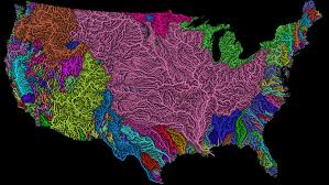
A drainage basin is any area of land where precipitation collects and drains off into a common outlet, such as into a river, bay, or other body of water.
The drainage basin includes all the surface water from rain runoff, snowmelt, and nearby streams that run down slope towards the shared outlet, as well as the groundwater underneath the earth’s surface.
Drainage basins connect into other drainage basins at lower elevations in a hierarchical pattern, with smaller sub- drainage basins, which in turn drain into another common outlet.
Other terms used interchangeably with drainage basin are catchment area, catchment basin, drainage area, river basin, and water basin. In North America, the term watershed is commonly used to mean a drainage basin, though in other English-speaking countries, it is used only in its original sense, that of a drainage divide.
Read Also : Definition of Corrosion and Causes of Corrosion in Waste-water Treatment Plant
In a closed drainage basin, or endorheic basin, the water converges to a single point inside the basin, known as a sink, which may be a permanent lake, a dry lake, or a point where surface water is lost underground.
The drainage basin acts as a funnel by collecting all the water within the area covered by the basin and channeling it to a single point.
Each drainage basin is separated topographically from adjacent basins by a perimeter, the drainage divide, making up a succession of higher geographical features (such as a ridge, hill or mountains) forming a barrier.
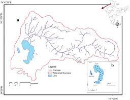
Drainage basins are similar but not identical to hydrologic units, which are drainage areas delineated so as to nest into a multi-level hierarchical drainage system. Hydrologic units are defined to allow multiple inlets, outlets, or sinks. In a strict sense, all drainage basins are hydrologic units but not all hydrologic units are drainage basins.
Drainagepatternandcatchmentmapping
About 48.7% of the world’s land drains to the Atlantic Ocean. In North America, surface water drains to the Atlantic via the Saint Lawrence River and Great Lakesbasins, the Eastern Seaboard of the United States, the Canadian Maritimes, and most of Newfoundland and Labrador.
Nearly all of South America east of the Andes also drains to the Atlantic, as does most of Western and Central Europe and the greatest portion of western Sub-Saharan Africa, as well as Western Sahara and part of Morocco. The two major Mediterranean seas of the world also flow to the Atlantic:
The Caribbean Sea and Gulf of Mexico basin includes most of the U.S. interior between the Appalachian and Rocky Mountains, a small part of the Canadian provinces of Alberta and Saskatchewan, eastern Central America, the islands of the Caribbean and the Gulf, and a small part of northern South America.
Read Also : Meaning and Concepts of Design of Waste-water Treatment Units
The Mediterranean Sea basin includes much of North Africa, east- central Africa (through the Nile River), Southern, Central, and Eastern Europe, Turkey, and the coastal areas of Israel, Lebanon, and Syria.
The Arctic Ocean drains most of Western and Northern Canada east of the Continental Divide, northern Alaska and parts of North Dakota, South Dakota, Minnesota, and Montana in the United States, the north shore of the Scandinavian peninsula in Europe, central and northern Russia, and parts of Kazakhstan and Mongolia in Asia, which totals to about 17% of the world’s land.
Just over 13% of the land in the world drains to the Pacific Ocean. Its basin includes much of China, eastern and southeastern Russia, Japan, the Korean Peninsula, most of Indochina, Indonesia and Malaysia, the Philippines, all of the Pacific Islands, the northeast coast of Australia, and Canada and the United States west of the Continental Divide (including most of Alaska), as well as western Central America and South America west of the Andes.
The Indian Ocean’s drainage basin also comprises about 13% of Earth’s land. It drains the eastern coast of Africa, the coasts of the Red Sea and the Persian Gulf, the Indian subcontinent, Burma, and most of Australia.
