Definition, Sources and Components of Runoff
Two of the major pathways of precipitation received on the Earth’s surface are infiltration and evaporation, as was discussed in the preceding units. The third major pathway is runoff, which shall be the focus of this article.
The discussions shall centre on sub topics such as definition of runoff, quick flow and delayed flow, sources and components of runoff.
Definition of Runoff
Runoff or stream flow comprises gravitation movement of water in channels, varying in size from those containing the smallest ill-defined trickles to those containing the largest rivers such as the Amazon or the Congo (Ward and Robinson, 2000).
Runoff, which is also known as stream flow, stream or river discharge, or catchment yield, can simply be referred to as the movement of water over the Earth’s surface.
The point to be stressed here is that they all mean the same because they tell us on how water moves from one place to the other on the Earth surface.
The unit area over the earth surface which has been found to be most convenient for monitoring water flow is the river basin – the boundary of a river system.
Generally, water within the basin is separated into various components. There is the channel flow, which is common in rivers and streams. There is surface runoff, which is mostly experience on land after rain.
It could be in form of sheet flow or channel flow. Runoff is important in hydrological study because they are the causes of major environmental problems experience on the landscape.
Quick flow and Delayed flow
The immediacy of stream flow response to a rainfall event indicates that part of the rainfall takes a rapid route to the stream channels (i.e. quick flow); equally, the subsequent continuity of flow through often prolonged dry weather period indicates that another part of the rainfall takes a much slower route as delayed flow, which is more usually referred to as base flow.
These two components of flow are apparent in rivers of all sizes. However, in large river systems lag effects, both within and outside channels, and the multiplicity of flow contributions to the main channel from numerous tributary streams complicate interpretation of the hydrograph response of major rivers to precipitation.
It is estimated that globally an average of 36 percent of the total precipitation falling on the land areas reaches the oceans as runoff. Of this amount, quick flow accounts for about 11 percent and delayed flow accounts for the remaining 25 percent of precipitation (Ward and Robinson, 2000).
Sources and Components of Runoff
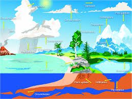
The variable response of stream flow to precipitation, both spatially and with time, reflects the contrasting flow paths of precipitation towards the stream channels. Precipitation may arrive in the stream channel by a number of flow paths: direct precipitation onto the water surface, overland flow, shallow subsurface flow (through flow); and deep subsurface flow (groundwater flow).
The relative importance of these sources of runoff may vary spatially, depending upon drainage basin characteristics, such as soil type and the nature and density of the vegetation cover, and upon precipitation conditions.
Read Also : Soil Conservation: Meaning, Categories and Soil Management Practices
In addition, the importance of individual runoff sources may vary with time, for example over a period of years or seasonably, and may also change quite dramatically during an individual storm or sequence of rainfall events in response to variations of infiltration capacity, water table levels and surface water area.
Channel Precipitation
The contribution of precipitation falling directly on to water surfaces is normally small simply because the perennial channel system occupies only a small proportion (1-2 percent) of the area of most catchments.
Even so, for small precipitation events channel precipitation may be the only component of the hydrograph. The channel system is more extensive where catchments contain a large area of lakes or swamps and in these circumstances; channel precipitation will tend to be a more dominant component of runoff.
In addition, channel precipitation will increase significantly during a prolonged storm or sequence of precipitation events, as the channel network expands, and may temporarily account for 60 percent or more of total runoff in some small catchments.
Over land Flow
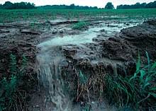
Overland flow comprises the water that flows over ground surface to stream channels either as quasi-laminar sheet flow or more usually, as flow anastomosing in small trickles and minor rivulets.

One cause of overland flow is the inability of water to infiltrate the surface as a result of a high intensity of rainfall and/or a low value of infiltration capacity. Ideal conditions are found on moderate to steep slopes in arid and semi-arid areas.
Here, vegetation cover may be sparse or non-existent, exposing the surface to raindrop impact and crusting processes.
Other conditions in which overland flow assumes considerable importance involve the hydrophobic nature of some very dry and sodic soils, the deleterious effects of many agricultural practices on infiltration capacity, and freezing of the ground surface.
In humid area, vegetation cover is thicker and more substantial and because of the high value of infiltration, which characterizes most vegetation – covered surfaces, overland flow is rarely observed, even in tropical rainforest (Anderson and Spencer, 1991), quoted from (Ward and Robinson 2000).
Read Also : Methods of Disposal of Waste Pesticide Containers
However, there are many areas, both humid and sub-humid, where the effects of topography or the nature of the soil profile facilitate the rise of shallow water tables to the ground surface during rainfall or through flow events. In such conditions the infiltration capacity at the ground surface falls to zero and saturation overland flow result.
Though flow
Water that infiltrates the soil surface and then moves laterally through the upper soil horizon towards the stream channels, either as unsaturated flow or, more usually, as shallow perched saturated flow above the main groundwater level, is known as through flow. Alternative terms found in the literature include interflow, subsurface storm flow, storm seepage and secondary base flow.
Through flow is liable to occur when the lateral hydraulic conductivity of the surface soil horizons greatly exceeds the overall vertical hydraulic conductivity through the soil profile.
Then, during prolonged or heavy rainfall on a hill slope, water will enter the upper part of the profile more rapidly than it can drain vertically through the lower part, thus accumulating and forming a perched saturated layer from which water will ‘escape’ laterally, i.e. in the direction of greater hydraulic conductivity.
Ground water Flow
Most of the rainfall that infiltrates the catchment surface will percolate through the soil layer to the underlying groundwater and will eventually reach the main stream channels as groundwater flow through the zone of saturation.
Since water at depth can move only very slowly through the ground, the outflow of groundwater into the stream channels may lag behind the occurrence of precipitation by several days, weeks or even years.
Groundwater flow tends to be very regular, representing as it does the outflow from the slowly changing reservoir of moisture in the soil and rock layers. In general groundwater flow represents the main long-term component of total runoff and is particularly important during dry spells when surface runoff is absent.
In summary, the sources of runoff identified above include direct precipitation, overland flow, through flow and groundwater flow. These sources are however influenced by the characteristics of the drainage basin, such as soil type, nature and density of the vegetation cover, and upon precipitation conditions.
In areas where the soils are compact or where the macro and micro pores of the soil has been sealed up due to trampling, vehicular movement and other human activities, runoff generation is usually high as a result of low infiltration. This explains why there is higher runoff in urban centres than in rural areas.
Runoff comprises the gravitation movement of water in channel in varying sizes.
Quick flow involves rapid flow of precipitation to stream channel, while delayed flow involves a much slower flow.
The major sources of runoff include channel precipitation, overland flow, through flow and groundwater flow. These sources are influenced by the nature of the drainage basin characteristics, which include soil, precipitation and plant cover.


