Air Quality Assessment Technologies
The environment and public health is greatly impacted by air quality. The purpose for the assessment of air quality is to reduce the negative effects of air pollution.
The data generated from air quality assessment help the government and other regulatory authorities to develop legislation, policies, and plans to manage emissions and monitor ambient air quality.
Air quality assessments inform air quality management activities by providing an understanding of how pollutant sources, emission characteristics, topography and meteorological conditions contribute to local air quality.
Specific air quality assessment tools can help answer a variety of questions which are integral to air quality management activities.
Air Quality Assessment Technologies
1. Air Quality Assessment Tools
Air quality assessment tools can help provide information on important sources, emissions, as well as meteorological conditions that contribute to poor local air quality.
Information generated from the use of air quality assessment tools can inform decisions on permitting of emissions, industrial siting, and land use; all can impact local air quality, which in turn can influence air pollution related health effects of a population.
The main tools for air quality assessment are:
Emissions inventories/measurement;
Source apportionment;
Mobile monitoring;
Land use regression;
Dispersion models.
All these assessment tools are interdependent in scope and application. Accordingly, all these tools should be regarded as complementary components in any integrated approach to exposure assessment or determining compliance against air quality criteria.
Emission Inventories
A crucial component of an air quality management plan is a reasonable quantitative knowledge of the sources of the various emissions. Emissions inventories are databases of pollution sources located within a specific geographical area, along with their estimated or actual emissions.
The pollutants included in inventories generally include the criteria pollutants, such as PM (PM2.5 and PM10), So x, NOx, VOCs, CO, NH 3, and ozone. Sources of emissions are organized into stationary and mobile categories, with stationary sources further broken down into point and area sources.
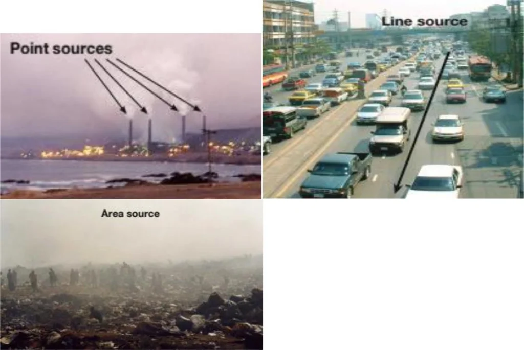
Point sources include larger facilities, such as pulp mills, smelters, power plants; wood products plants and stacks in major industrial sites (Figure 1.1).
Area sources include stationary sources that are too small and numerous to count individually e.g. forest fires, emissions from vehicle refueling, on-road vehicles, commercial and domestic fuel combustion (see Figure 1).
Mobile sources include any sources powered by an internal combustion engine that move under their own power; these include all on-road vehicles, off-road vehicles (e.g., construction equipment, sports equipment, gardening equipment) etc.
Mobile sources are often considered as line sources as it is not practicable to consider the emissions from each car separately but rather to sum up the emissions along the road (considered as a line; see Figure 1.1).
Read Also : Tools for Air, Water and Soil Analysis
Biogenic or natural sources, such as deserts, eroded areas, and agricultural emissions are a non-anthropogenic source category, mostly being to area sources.

Pollutant emissions from each source are calculated using a variety of data. For point sources, data generally come from stack sampling and monitoring, as required of larger facilities by the permitting process.
For point sources where stack monitoring data is not available, such as smaller facilities that are not required to conduct monitoring, estimation methods are used to calculate emissions rates of pollutants.
The use of monitoring data allows for more accurate calculations of emissions from facilities, compared with those generated by estimation methods.
These methods typically include the use of emission factors and a production or activity level. Form any common industrial processes and control equipment, an existing emission factor can be found for similar facilities.
For example, the United States Environmental Protection Agency (USEPA) maintains a large database of these factors, called the AP-42 Emission Factors (US EPA, 2010). Emission factors are usually expressed as a mass of contaminant emitted per unit of input energy or raw material consumed (called the activity level).
Once the emission factor and activity rate are known, the overall emissions from a source or activity can be calculated using equation 1 (US EPA, 2010).
Equation 1 also takes into consideration emissions reduction activities which can reduce total emissions.
Where:
E = emissions;
A = activity rate;
EF = emission factor, and
ER = overall emission reduction efficiency, %
Emissions, from the majority of area sources in inventories, are estimated using emission factors and activity levels or a simple count of the number of facilities within the area of study.
Emissions from sources in specialized categories, such as open burning, can be estimated with models. All mobile source categories are estimated with models developed for each category (i.e., on-road, off-road, aircraft, etc.).
While these models are based on empirical data and emission factors, they do take into account relevant local data, including: vehicle fleet distribution and demographics, average vehicle use cycles and mileage, fuel characteristics, average weather, and changing engine emission criteria and limits.
Similarly, estimations of emissions from natural sources, such as forest fires, are generally calculated using models (e.g., vegetation growth) or a combination of empirical data and emission factors.
Once the inventory has been completed it is important to conduct an emissions verification exercise to ensure that the accuracy and precision of estimates remain within acceptable parameters.
Verification involves ascertaining the completeness and consistency of the data input and involves checks on:
How definitions of sources and of pollutants have been applied;
The completeness of the data entered for each sector, sub-sector and activity;
The consistency of the inventory at different levels of spatial disaggregation;
The transparency of the emissions inventory whether the data inputs are fully traceable to their references.
Verification can also involve the use of dispersion and modelling studies to assess the inventory in relation to measured air quality.
In summary, data collected in emissions inventories can be used to understand emissions trends over time, as well as highlight sources that require targeted emission reduction interventions.
While on their own, they do not provide information on ambient concentrations. Emissions inventories can feed into other assessment tools, such as dispersion models, to better characterize pollutant concentrations.
Read Also : Comprehensive Seed Farm Guide For Farmers


